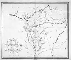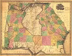
The Federal Roads refers to two roads that were established by the United States government in the mid-1800s to facilitate westwards expansion from Georgia into Tennessee and Alabama. Prior to the 1790s and 1800s the United States remained a country that was largely confined to the East Coast of the modern-day United States, though movement was underway and growing to expand westwards towards the Great Lakes and into places like West Virginia, Ohio, Kentucky, Tennessee and Alabama. Two Federal Roads were planned, one to run through the territory of the Cherokee Native Americans from Georgia to what is now Knoxville in Tennessee, and another through the lands of the Creek from Georgia to Mobile in Alabama. The Creek Federal Road was never fully completed. Nevertheless, the two Federal Roads expanded American and European settler migration westwards into Tennessee and especially Alabama in the 1810s and 1820s. It also began the process whereby the Five Civilized Tribes (the Cherokee, Creek, Chickasaw, Choctaw and Seminoles) were supplanted and moved west of the Mississippi River.[1]
Research your ancestors on MyHeritage
Federal Roads chronology of eventsFederal Roads chronology of events
When the United States was ushered into being with the Declaration of Independence on the 4th of July 1776, the new country was basically tied to the East Coast of North America. The thirteen founding states ran from New Hampshire in the north to Georgia in the south. All of them had an Atlantic coastline. There were, however, moves underway to press further inland by settlers already at that time, with a few intrepid pioneers venturing over the Cumberland Gap and other passes in the Allegheny Mountains to Kentucky and Tennessee. This process accelerated in the 1790s and 1800s as the population of the country grew quickly and new lands were needed. Some headed towards the Great Lakes, while others further south moved into Ohio, West Virginia, Kentucky, Tennessee and Alabama.[2]
The Federal Roads were established in the southern part of this catchment area. The plan was for two separate roads. The more northerly one would run through the territory of the Cherokee Native Americans. It would start at Savannah, Georgia and go westwards to Knoxville, Tennessee. The more southerly road would commence at Midgeville, Georgia, specifically at Fort Wilkinson there, and traverse the way west to Mobile in Alabama. Fort Wilkinson had only been established in 1797 and was used as a trading and administrative station for relations with the Creek people, through whose lands this more southern road was intended to run.[3]

These roads were deemed important to set up, as the US government was anxious to strengthen communication and transport between Georgia and the city of New Orleans in Louisiana, which had just been acquired from the French via the Louisiana Purchase of 1803. New Orleans was quite isolated form the rest of the country and best accessible by sea. The idea of the Federal Roads was to encourage further settlement in Tennessee and Alabama and also to strengthen the land connections between Georgia and Louisiana.[4]
The more northerly Federal Road through the lands of the Cherokee to Knoxville was commenced in 1803 and completed by 1805. It continued to operate down to the 1840s, by which time the Cherokee had been largely removed from Tennessee via the Indian Removal Act of 1830 and the Trail of Tears that followed it. Prior to this the road had brought settlement along the route as people set up inns, stables and other services to facilitate the mail coaches that passed through along with other traffic. The southerly road through Creek territory was only ever partially completed. It functioned as a route-way, but it was not wide or well finished, so was not overly practical for wagons and stage coaches to pass along.[5]
Extent of migration along the Federal RoadsExtent of migration along the Federal Roads

These two regions experienced a flood of migration in the 1810s, 1820s and 1830s, though the extent to which this can be attributed to the development of the Federal Roads is very debatable. No doubt they facilitated it, yet they hardly caused it. Alabama, in particular, experienced a massive influx of settlers from 1817 onwards. People came in search of land for cotton cultivation as prices for the crop surged as the Industrial Revolution expanded back in Europe and the Old World developed an insatiable need for the crop that fed its factories to produce cheaper textiles.[6]
In 1810, there were only around 10,000 people of European heritage living in what is now the state of Alabama. That number had ballooned to around 300,000 by 1830.[7] So swift was the influx of people into the region that Alabama was made a state in 1819, a very quick admission to the Union for a newly settled land. So rapid was this influx into Alabama that the drive for cotton-producing lands here was known as ‘Alabama Fever’, like the later gold, silver and oil fevers or rushes of the American West, while it also caused one of the first real estate bubbles in US history as land prices quadrupled and then collapsed dramatically at the time of the Panic of 1819.[8]
Demographic impact of the Federal RoadsDemographic impact of the Federal Roads
The demographic impact of the Federal Roads is hard to gauge. As is clear, Tennessee and Alabama experienced a flood of migration between 1805, when the roads were first opened for use, and the 1840s when they largely became obsolete. Nevertheless, this would have happened anyway, regardless of whether or not the Federal Roads had been set up. There was simply too much demand for land in a country the population of which expanded from just over five million people at the turn of the century to heading on for thirteen million by 1830.[9] Alabama, as a very thinly settled region adjacent to Georgia, was one of the obvious places for newcomers to the country from Europe to head to in search of land. All that the Federal Roads did was get people to where they were going slightly faster, though this was inconsequential in and of itself.
See alsoSee also
Explore more about the Federal RoadsExplore more about the Federal Roads
- Georgia, Births and Christenings, 1754-1960 records collection on MyHeritage
- Alabama, Marriages, 1816-1957 records collection on MyHeritage
- Tennessee, Rutherford County Marriages, 1810-1940 records collection on MyHeritage
- Georgia: Gateway to Westward Expansion at Legacy Family Tree Webinars
- The Two Colonial Georgias at Legacy Family Tree Webinars
- Researching Your Tennessee Ancestors at Legacy Family Tree Webinars
- Understanding Alabama at Legacy Family Tree Webinars
References
- ↑ Angela Pulley Hudson, Creek Paths and Federal Roads: Indians, Settlers, and Slaves and the Making of the American South (Chapel Hill, 2010).
- ↑ Peter J. Kkastor, ‘“What Are the Advantages of the Acquisition?”: Inventing Expansion in the Early American Republic’, in American Quarterly, Vol. 60, No. 4 (December, 2008), pp. 1003–1035.
- ↑ Hudson, Creek Paths.
- ↑ https://www.monticello.org/thomas-jefferson/louisiana-lewis-clark/the-louisiana-purchase/
- ↑ https://www.pbs.org/wgbh/aia/part4/4p2959.html
- ↑ https://encyclopediaofalabama.org/article/cotton/
- ↑ https://encyclopediaofalabama.org/article/alabama-fever/
- ↑ Gordon T. Chappell, ‘Some Patterns of Land Speculation in the Old Southwest’, in The Journal of Southern History, Vol. 15, No. 4 (1949), pp. 463–477.
- ↑ https://www.census.gov/about/history/historical-censuses-and-surveys/decade-facts.1830.html

